Most country towns have a main street, a war memorial and a pub. Mount Gambier has those too, but it also has a lake in a volcanic crater that turns a shade of blue you would not believe from a photograph, a garden at the bottom of a collapsed cave, another sinkhole in the middle of the shopping district and a network of flooded caverns running under the houses. South Australia’s second city sits on the slopes of a volcano in the far south-east of the state, close to the Victorian border, and it is one of the most quietly remarkable places in the country.
This guide covers what to see in and around the city: the Blue Lake and the other crater lakes, Umpherston Sinkhole, the Cave Garden, Engelbrecht Cave, the places you can actually swim, the nearby volcanic cone at Mount Schank and the caves and coast within half an hour’s drive. It also covers getting there from Adelaide, how long to stay and what is on. Prices and opening hours were checked in October 2026 against the City of Mount Gambier, its visitor site, Parks SA and the South Australian Tourism Commission; check again before you go.
Mount Gambier at a Glance
| Attraction | What it is | Cost | Time to allow |
|---|---|---|---|
| Blue Lake / Warwar | Crater lake with a 3.6km rim road and walking track | Free | 1–2 hours |
| Umpherston Sinkhole / Balumbul | Sunken garden in a collapsed limestone cave | Check the council’s visitor site | 30–60 minutes |
| Cave Garden / Thugi | Sinkhole garden in the city centre | Free to view | 15–30 minutes |
| Engelbrecht Cave | Guided tour of caves under the city | A$22 adult, A$11 child (2026–27) | About 30 minutes for the tour |
| Valley Lake / Ketla Malpi | Crater lake with grassed area, playground, barbecues and walks | Free | 1–2 hours |
| Little Blue Lake | Swimming sinkhole on Mount Salt Road | Free | An hour or so |
| Tantanoola Caves (30 minutes away) | Decorated cave, wheelchair accessible | A$17.50 adult | 1–2 hours with the drive |
Getting to Mount Gambier from Adelaide
By car
Mount Gambier is roughly 450km from Adelaide and about 435km from Melbourne, so it sits roughly halfway between the two state capitals. There are two ways to drive it from Adelaide: inland on the Dukes and Riddoch Highways via Keith, Naracoorte and Penola, or along the coast on the Princes Highway via the Coorong, Kingston SE, Robe and Millicent. Either way it is the best part of a day’s driving, so most people break the journey or build Mount Gambier into a longer loop. Our Limestone Coast road trip does exactly that, out by the coast and back through Coonawarra and the Naracoorte Caves.
A car is also the easiest way to see the city itself. The Blue Lake, Valley Lake and Mount Schank are a short drive from the centre, and the caves, coast and wineries further out are not practical without one. Our guides to car rental in Adelaide and driving in South Australia cover the basics.
By air or coach
Regional Express (Rex) flies between Adelaide and Mount Gambier; check its website for the current timetable and fares, as regional schedules change. Stateliner runs coaches between Adelaide Central Bus Station and Mount Gambier; check stateliner.com.au for routes and days. Flying in and hiring a car in Mount Gambier is a sensible option if you have only a weekend.
A City on a Volcano
Mount Gambier is built around a volcanic complex: a cluster of craters on the southern edge of the city, now filled by lakes and surrounded by parkland and walking trails. The city’s visitor site lists four of them with dual names: the Blue Lake (Warwar), Valley Lake (Ketla Malpi), Leg of Mutton Lake (Yatton Loo) and Browne Lake (Kroweratwari). The same dual naming now runs through the city’s other natural landmarks, so you will see Umpherston Sinkhole signposted as Balumbul and the Cave Garden as Thugi.
Below the volcanic rock lies limestone, and that is the other half of the story. Groundwater moving through the limestone has hollowed out caves under the city, and where cave roofs have collapsed, sinkholes have opened at the surface. It makes for an unusual town to wander around: around 29,000 people live in the Mount Gambier urban area, according to the 2021 Census, many of them on top of a cave system.
The Blue Lake / Warwar
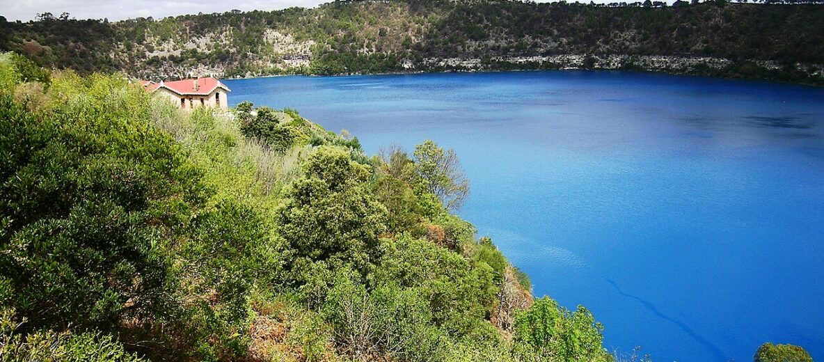
The Blue Lake is the reason most people come, and it lives up to the hype. It fills a crater on the city’s southern edge, off John Watson Drive, and a 3.6km road and walking track loops around the rim, with lookouts around the lake. Walk the full loop if you can; it is the best way to see the lake from different angles and in changing light.
When is the Blue Lake bluest?
The lake is not always the same colour. According to the South Australian Tourism Commission, each November it changes from a darker blue to an intense turquoise, and it stays that way until late February. If you have a choice of when to visit, those summer months are the time; outside them the lake is still beautiful, just a deeper, steelier blue.
Why is it blue?
Nobody claims to have a complete answer. The City of Mount Gambier’s 2004 Crater Lakes conservation management plan calls the colour change “somewhat of a mystery” and describes the explanations that have been put forward: a layering of the water by temperature that sets up from November, and tiny calcite crystals forming in the water as it warms, which scatter blue light. It is a good example of a place where the science makes the view more interesting, not less.
Practical details
- Cost: free.
- Blue Lake Welcome Centre: on John Watson Drive, open 10am to 3pm on weekends and public holidays only (closed Christmas Day). On weekdays, use the Mount Gambier Visitor Centre in town.
- Water supply: the lake is the principal water supply for the city, so treat it as a lake to look at rather than one to swim in. For a swim, head to Little Blue Lake (below).
- Tours: for current tours and anything else on offer, ask at the Mount Gambier Visitor Centre.
Umpherston Sinkhole / Balumbul
Umpherston Sinkhole is a collapsed limestone cave on the Jubilee Highway East that was turned into a sunken garden, and the result is one of the most picturesque spots in the region. Terraced lawns and flower beds fill the floor of the sinkhole, curtains of creepers hang down the walls, and a steep staircase takes you from the rim to the bottom.
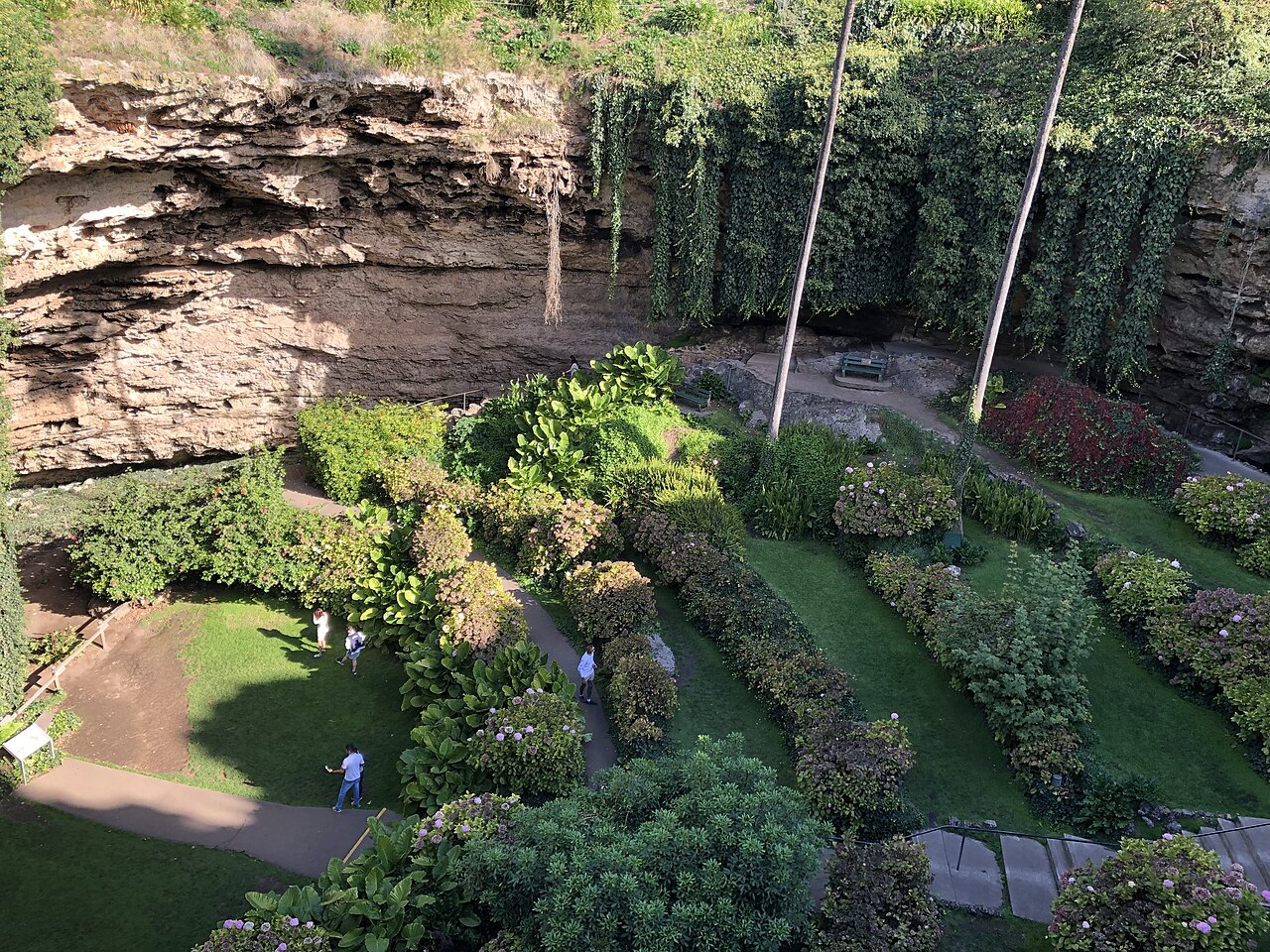
A few things to know before you go. The staircase is steep, so it is not suitable for everyone, although the view from the rim is excellent on its own. Dogs are not permitted. The council runs a staffed servicing point at the sinkhole from 10am to 3pm daily (closed Christmas Day). For current opening times and any charges, check the City of Mount Gambier’s visitor site.
Our verdict: do not skip it, and if you have time, come twice, once in the morning light and once later in the day when the shadows fill the bowl. It is a short drive or a longish walk from the city centre.
Cave Garden / Thugi
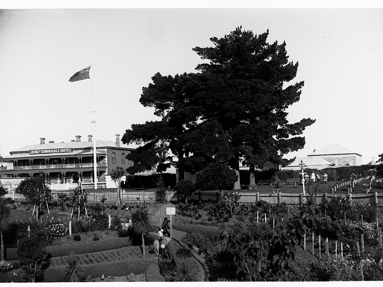
The Cave Garden is a smaller sinkhole right in the middle of the city, at 6 Bay Road on the south side of The Riddoch Arts and Cultural Centre. You can look down into it from the viewing platform or follow the path down into the garden. After significant rain, water pours over the edge as a waterfall into the sinkhole. It is a five-minute stop if you are in town anyway, and a good excuse to look into The Riddoch, the city’s arts and cultural centre next door; check the council’s site for its opening hours.
Engelbrecht Cave
Engelbrecht Cave runs under the streets of Mount Gambier, and it is the city’s most accessible way to see what lies beneath the surface. It is at 26–32 Chute Street, and the City of Mount Gambier has run it since July 2024. Guided tours of the dry eastern and western caves take about 30 minutes, and bookings are essential online. Dogs are not permitted.
The council’s 2026–27 schedule of fees puts the tour at A$22 for adults, A$17.30 for concession holders and A$11 for children aged 4 to 16, with under-fours free. The cave is also a cave-diving site; qualified divers should contact the council about access.
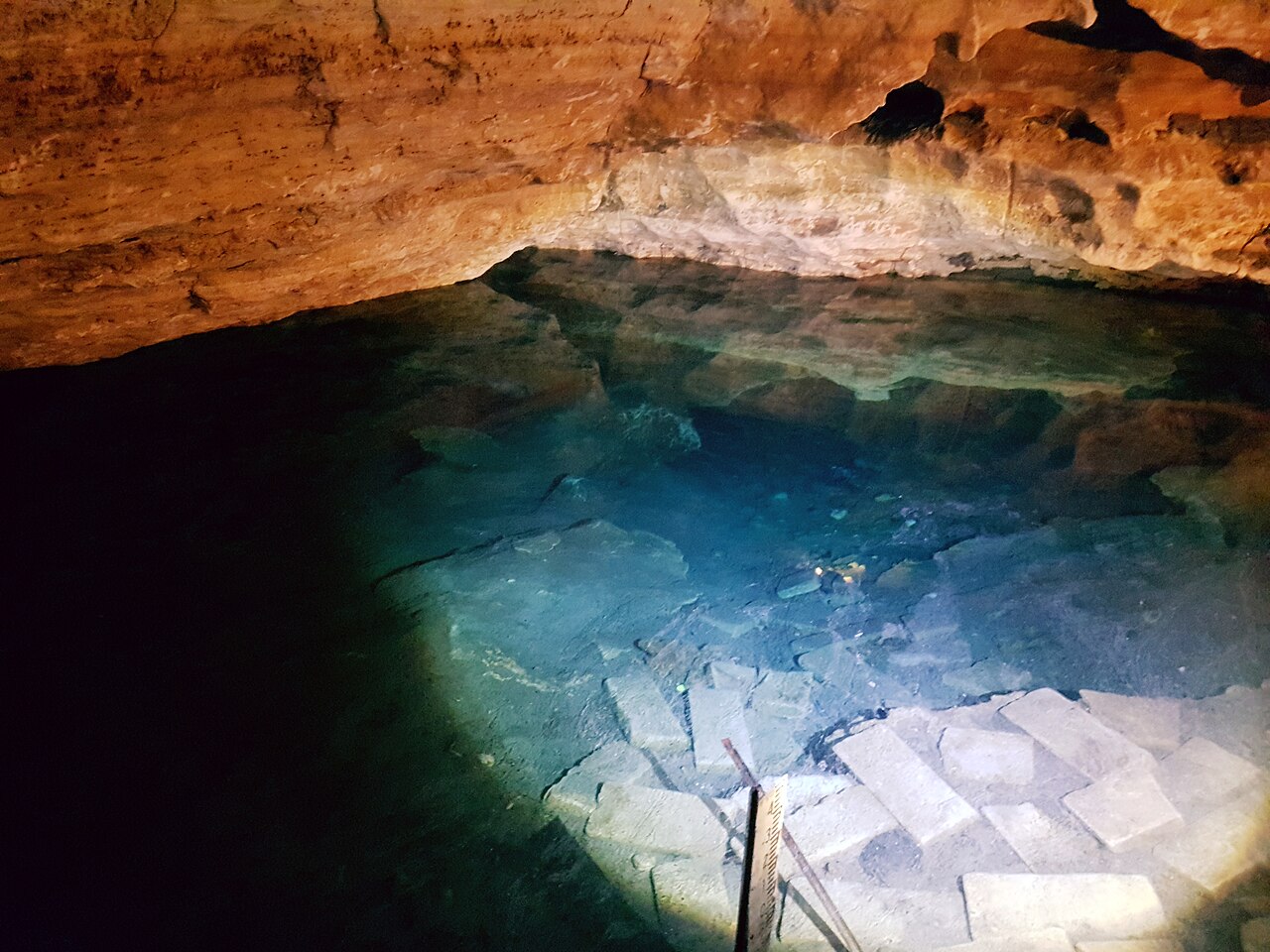
Is it worth it? If you have not been in a cave before, yes: it is short, close to the centre and well suited to children. If you are also planning to visit Naracoorte or Tantanoola, think of Engelbrecht as the city-centre extra rather than the main event; those caves are larger and more decorated.
Valley Lake / Ketla Malpi, Centenary Tower and the Other Crater Lakes
Next to the Blue Lake, Valley Lake is the crater the city actually uses for outings, with a grassed area, a playground and barbecues by the water and walking tracks through the surrounding Valley Lake Conservation Park. It is the easiest place in Mount Gambier to spend a relaxed couple of hours with children.
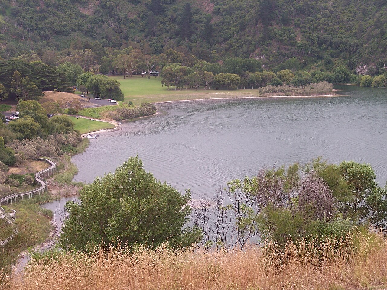
Above the lakes, the Centenary Tower sits on the rim of the volcanic crater. The visitor site describes the walk up as short but steep, and the tower as open when its flag is flying, with a small entry fee. On a clear day the view over the city, the crater lakes and the surrounding farmland is worth the climb. Leg of Mutton Lake and Browne Lake complete the set of craters; they are less visited and best seen from the walking trails.
Where to Swim: Little Blue Lake and Kilsby Sinkhole
If the Blue Lake has you wishing you could jump in, there are two places where you can get in the water.
- Little Blue Lake, on Mount Salt Road south of the city, is a water-filled sinkhole with a staircase and a pontoon for swimmers. It is very deep, and the South Australian Tourism Commission advises that it is for experienced swimmers only. On a hot summer afternoon, it is a local favourite.
- Kilsby Sinkhole is on private farmland and can only be visited on a tour. Its operators run guided dives and snorkels with certified guides, as well as above-water tours, and bookings are essential. Prices and tour times are published through the operator’s own booking page, linked from the city’s visitor site.
Piccaninnie Ponds, the famous clear-water snorkelling site near the Victorian border, is closed to diving and snorkelling until further notice, and Parks SA is not issuing permits. The conservation park itself is open, but check the Parks SA page before you plan a visit around getting in the water.
Around Mount Gambier
Mount Schank
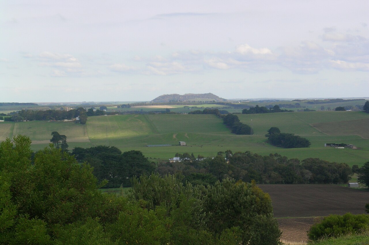
Mount Schank is a smaller volcanic cone just south of the city, on the road to Port MacDonnell. The city’s visitor site calls it Australia’s youngest volcano, last erupting more than 4,500 years ago, and a signposted walk of about 900 metres takes you up to the crater rim. It is a good short walk for the view back over the flat, green countryside to Mount Gambier.
Port MacDonnell
Carry on past Mount Schank and you reach the coast at Port MacDonnell, a rock lobster fishing town with a long foreshore and a quiet harbour. It is a good place for a walk and a seafood lunch, and it puts you within reach of the coastal scenery on the border with Victoria.
Tantanoola Caves
About 29km north-west of the city off the Princes Highway, Tantanoola Caves Conservation Park has a single richly decorated cave whose formations are tinted pink and brown. Parks SA describes it as one of Australia’s few wheelchair-accessible caves. Tours run daily from 10am to 3pm (closed Christmas Day), and Parks SA lists tickets at A$17.50 for adults, A$14.50 concession and A$10 for children aged 4 to 15, with under-fours free.
Coonawarra and Naracoorte
North of the city on the Riddoch Highway, the Coonawarra wine region starts around Penola, and Zema Estate describes it as about 40 minutes from Mount Gambier. Beyond it, the Naracoorte Caves, a World Heritage-listed fossil site, are an easy day trip or a stop on the way back to Adelaide. Our Coonawarra guide and Limestone Coast road trip cover both.
Mount Gambier with Kids
Mount Gambier is an easy city to visit with children, because almost everything is short, outdoors and free or cheap. A few pointers for planning a family day:
- Start at Valley Lake. The playground, barbecues and grassy areas by the water make it the natural base, and the walks around the lake can be as short as you like.
- Pick your section of the Blue Lake loop. The full 3.6km rim walk is a lot for small legs, so drive between lookouts instead and walk a short stretch.
- Engelbrecht Cave is the right length. At about 30 minutes, the guided tour holds children’s attention, and the child price is A$11. Remember to book online first.
- Think about the stairs. Umpherston Sinkhole’s staircase is steep, so if you have a pram or a toddler who will not walk back up, enjoy the view from the rim.
- Tantanoola Caves suits all ages. Because it is wheelchair accessible, it also works with a pram, and it is half an hour’s drive away.
- Little Blue Lake is not a paddling spot. It is deep, and the advice is experienced swimmers only, so choose a beach on the coast for younger children.
For more family ideas in and around Adelaide, see Adelaide family day trips.
Events in Mount Gambier
- AAM Timber Christmas Parade: Saturday 21 November 2026.
- Carols in the Pub: Saturday 12 December 2026, at the Mount Gambier Hotel.
- Generations in Jazz: the big band and youth jazz festival, scheduled for 30 April to 2 May 2027; see generationsinjazz.com.au for venues and tickets.
For everything else on, the city’s visitor site keeps a current events list.
The Mount Gambier Visitor Centre
The Mount Gambier Visitor Centre is at 35 Jubilee Highway East and is open Monday to Friday from 9am to 5pm, and from 10am to 4pm on weekends and public holidays (closed Christmas Day). Call 1800 087 187. It is the best first stop for maps, current opening times, tours and anything that has changed since you planned your trip.
How Long to Stay
One full day covers the essentials; two days lets you see the surrounding area properly. A good plan:
- Day one: the Blue Lake loop in the morning, Valley Lake and Centenary Tower before lunch, then Umpherston Sinkhole, the Cave Garden and an Engelbrecht Cave tour in the afternoon.
- Day two: south to Mount Schank and Port MacDonnell, with a swim at Little Blue Lake if it is warm, or north-west to Tantanoola Caves and on to the coast at Beachport.
Stay at least one night. The drive from Adelaide is long enough that a day trip makes no sense, and the city is at its best in the early morning and evening, when the day-trippers from the coast have gone.
Is Mount Gambier Worth Visiting?
Yes, and especially in summer. The Blue Lake at its brightest is one of the great natural sights of South Australia, and Umpherston Sinkhole is worth the trip on its own. The honest caveats are distance and scale: the city is a long drive from Adelaide, its main attractions can be seen in a day, and the centre itself is a working regional city rather than a postcard town. Visit it as part of a longer Limestone Coast trip with Robe, Coonawarra and the Naracoorte Caves, and it becomes the highlight of one of South Australia’s best road trips. For more ideas, see our South Australia road trips guide.
Frequently Asked Questions
How far is Mount Gambier from Adelaide?
Roughly 450km, which makes it the best part of a day’s drive by either the inland Dukes and Riddoch Highways or the coastal Princes Highway. Rex flies between the two cities and Stateliner runs coaches; check their sites for current timetables.
When is the Blue Lake at its bluest?
From November to late February. According to the South Australian Tourism Commission, each November the lake changes from a darker blue to an intense turquoise and stays that way until late February.
Why is the Blue Lake blue?
The City of Mount Gambier’s crater lakes management plan calls the colour change “somewhat of a mystery”. The main explanations are a temperature layering of the water that sets up from November and tiny calcite crystals forming in the warming water, which scatter blue light.
Can you swim in the Blue Lake?
The Blue Lake is the city’s principal water supply, so it is a lake for looking at, not swimming in. For a swim, try Little Blue Lake on Mount Salt Road, a deep sinkhole with a staircase and pontoon that is recommended for experienced swimmers only.
How much is Engelbrecht Cave?
Under the City of Mount Gambier’s 2026–27 fees, the guided tour costs A$22 for adults, A$17.30 concession and A$11 for children aged 4 to 16, with under-fours free. Tours take about 30 minutes and must be booked online.
How many days do you need in Mount Gambier?
One full day covers the Blue Lake, Valley Lake, Umpherston Sinkhole, the Cave Garden and Engelbrecht Cave. Allow two days to add Mount Schank, Port MacDonnell, Little Blue Lake or Tantanoola Caves.
Is Mount Gambier worth visiting?
Yes, particularly between November and February when the Blue Lake is at its most vivid. It works best as part of a longer Limestone Coast trip that includes Robe, Coonawarra and the Naracoorte Caves, rather than as a destination in its own right.
Related Adelaide Guides
- Limestone Coast Road Trip: Mount Gambier, Caves & Coonawarra
- South Australia Road Trips: The Complete Regional Guide
- Langhorne Creek & Coonawarra: SA’s Underrated Wine Regions
- Driving in South Australia: Rules, Tips & Road Trip Essentials
- Car Rental Adelaide: Complete Guide to Hire Cars
- Adelaide’s Best National Parks
Photo Credits
The Blue Lake (featured image): “Mount Gambier Blue Lake.jpg” by Roo72, via Wikimedia Commons, CC BY-SA 3.0.
Umpherston Sinkhole: “Umpherston sink hole garden SA.jpg” by Michele Lunam, via Wikimedia Commons, CC BY-SA 4.0.
The Cave Garden, archive photograph: “The Cave Gardens, Mount Gambier(GN13885).jpg” by State Government Photographer, via Wikimedia Commons, CC0.
Engelbrecht Cave, 2018: “Engelbrecht Cave, Mount Gambier, November 2018.jpg” by Satellizer, via Wikimedia Commons, CC BY-SA 4.0.
Valley Lake: “Valley Lake, South Australia.jpg” by Riana, via Wikimedia Commons, CC BY-SA 3.0.
Mount Schank: “Mount Schank viewed from Mount Gambier.jpg” by Roo72, via Wikimedia Commons, CC BY-SA 3.0.